
Altitudinal Zonation : Mountains and Verticality
![Illustration of altitudinal zonation for the Andes Mountains, drawn from the studies of Alexander von Humbolt.[1] Original image source.](https://images.squarespace-cdn.com/content/v1/5e1e5ef4c84b953ac52564ba/1609862836761-LNNFNWGAGW966J9NU15W/1850-AlexandervonHumboldt-Andes.jpg)
Illustration of altitudinal zonation for the Andes Mountains, drawn from the studies of Alexander von Humbolt.[1] Original image source.
The earth’s atmosphere is defined by vertical gradients. As one rises, the air thins out, humidity decreases, and temperatures drop. It’s why we get altitude sickness when we travel to high places, and it’s why the tops of very high mountains are snow-capped. If we would travel from sea-level to the summit of a high mountain, we would experience a loose set of vertical layers along the way, each with a specific set of environmental conditions based on the available oxygen, humidity, and temperatures. We call this vertical layering altitudinal zonation.
Altitudinal zonation was first hypothesized by German naturalist and explorer Alexander von Humboldt in 1805. During a five-year voyage from 1799-1803, Humboldt traveled around the world and noticed that plant life changes as one ascends away from sea-level, much in the same way it does when one travels from the equator towards the poles. The most dramatic of these changes can be found in the mountains, where great changes of altitude can happen quite quickly. Humboldt subsequently published his thoughts in 1805 with his Essay on the Geography of Plants. This essay explained his theory of altitudinal zonation, and included a detailed illustration of the hypothesis, called Tableau Physique, pictured below.
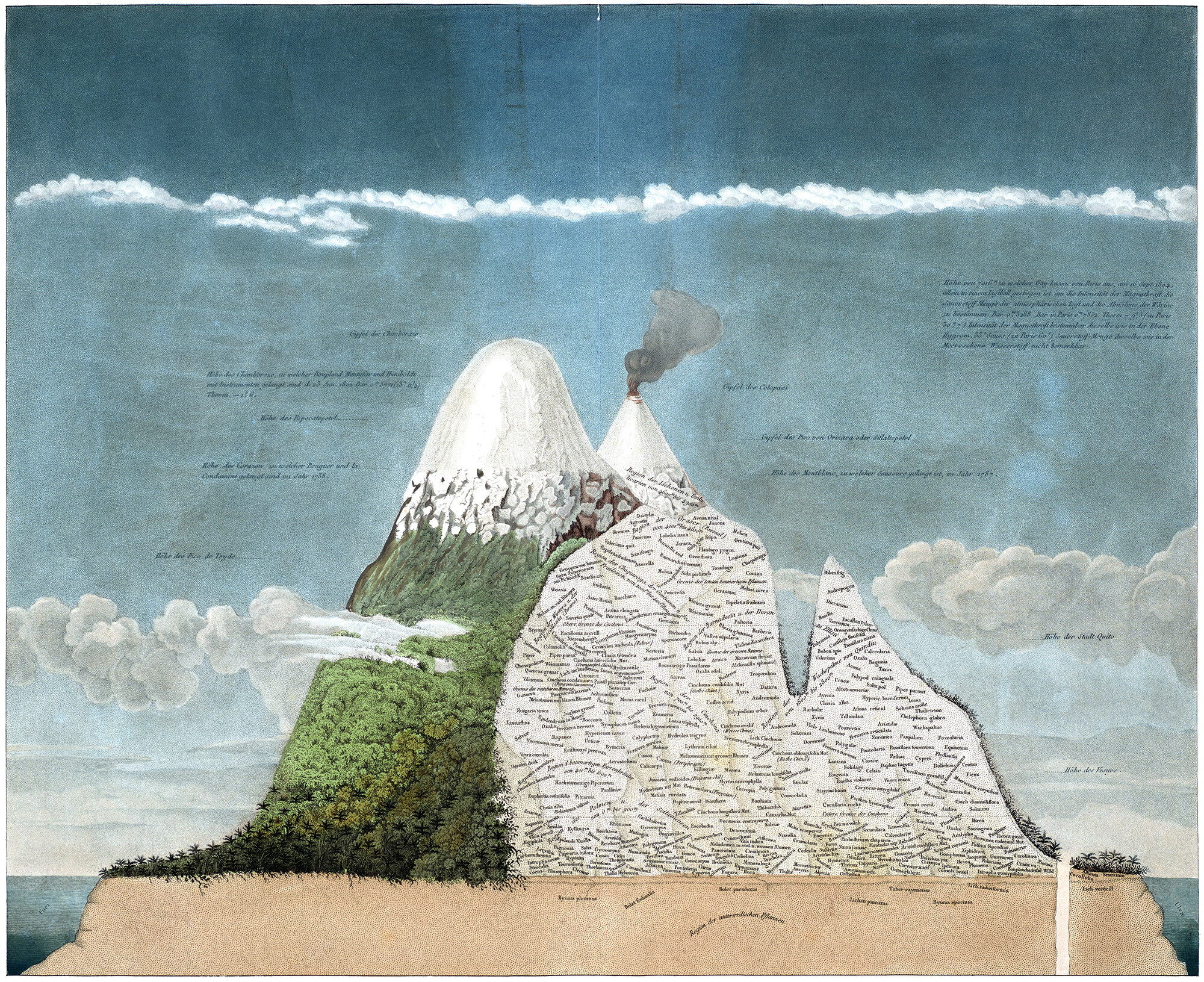
Alexander von Humboldt’s Tableau Physique, first published in 1805 as part of a compendium that described his world travels from 1799-1803. This image illustrates Humboldt’s theory of altitudinal zonation, after he observed that plant life changes as one ascends away from sea-level.
Humboldt’s theory is still with us today, but it’s been refined over the years as we’ve gained a better understanding of what causes it. The main refinements deal with the changes in zonation based on different locations around the world. In his Tableau Physique, Humbolt included plant species from multiple mountain ranges, and locked them all into specific elevations. He was trying to combine different environments together along a single vertical gradient, which we now know to be incorrect. Our environment is wonderfully complex and dynamic, so finding a common set of zones that appear everywhere on earth is impossible. You can see examples of it throughout this article, in the details of an 1850 engraving by W. & A.K. Johnston that illustrate this point. Each detail is from a different mountain range, and each one has a different configuration of layers. There are two main takeaways from this.
First, the layers don’t align with specific altitudes across the globe. This is because of varying environmental conditions, which is what the plant life is responding to. A vertical gradient always occurs, but the specific layers and their corresponding altitudes change depending on location.
Second, the layers themselves aren’t always horizontal. This is mainly due to sunlight and prevailing winds. The sunny side of a mountain will be warmer, and will be able to sustain plant life higher up than the shady side. Similarly, the windward side of the mountain will also be warmer, as warmer air from below is pushed up the mountainside. This also helps plant life grow at higher altitudes. Each mountain range has a specific climate and orientation, which creates a unique set of environments for plants to grow in.
![Illustration of altitudinal zonation for the Himalaya, drawn from the studies of Alexander von Humbolt.[1] Original image source.](https://images.squarespace-cdn.com/content/v1/5e1e5ef4c84b953ac52564ba/1609862564867-3Z4H4NYCM8R9PVFCKUB0/1850-AlexandervonHumboldt-Himalaya.jpg)
Illustration of altitudinal zonation for the Himalaya, drawn from the studies of Alexander von Humbolt.[1] Original image source.
It’s not all unique and varying, however. Throughout the world, we can define four major zones that occur as one ascends up and away from sea level. These are the lowlands, the montane, the alpine and the nival.
These four layers have diminishing diversity as one travels up them. Think of them like a pyramid; the lowest is the largest and most diverse, while the highest is the smallest and most consistent. The lowest of these is the lowlands, which can vary from lush, tropical rainforests to barren, dry deserts. There is the highest variety of moisture here, and this is generally the warmest of the four layers. Oxygen levels are also the highest here, so this layer can sustain dense forests with large trees.
Above the lowlands is the montane. This level still contains trees, and extends up to the tree line. The conditions are less habitable here, so vegetation grows at a slower rate, and not as tall as the lowlands. Animal populations are generally less diverse and often have specialized themselves to survive here. Montane forests are generally dominated by coniferous trees and more hardy types of plants that can withstand lower temperatures, such as mosses and ferns. There is a quietness and a stillness to the montane layer. Mosses and pine needles create good acoustics, and there’s a growing crispness in the air as one ascends through it.
![Illustration of altitudinal zonation for the Alps and Pyrenees Mountains, drawn from the studies of Alexander von Humbolt.[1] Original image source.](https://images.squarespace-cdn.com/content/v1/5e1e5ef4c84b953ac52564ba/1609863105512-QYIGT7SNPJLZER89L2C8/1850-AlexandervonHumboldt-Alps.jpg)
Illustration of altitudinal zonation for the Alps and Pyrenees Mountains, drawn from the studies of Alexander von Humbolt.[1] Original image source.
At the montane’s upper limit, we reach the tree line. Again, this isn’t an actual line, per se, but rather a gradual shrinking of the forest as the conditions become inhospitable for large plants to grow. Pines turn into shrubs, and shrubs turn into ground plants, leaving us at the alpine level. The alpine level exists between the tree line and the snow line. Temperatures are lower here, and frost is common in the higher regions. Alpine zones can be loosely divided into two parts. The low-alpine generally has a full ground cover of plant life, including grasslands and the occasional small tree. The lack of forest exposes the ground to the wind, which limits the types of plants that can survive here. Temperatures are also dropping, and frost is a growing factor as we continue to climb. Above the low-alpine is the sub-nival, which is the highest layer that supports vegetation. Plant life is patchy and limited to places with the best conditions, usually protected from the wind. Speaking of wind, it’s quite windy here. The quiet, calm montane forest has become wind-whipped and largely barren. Snow is common here during the colder months, and only a few animals can survive on the lack of plant life here.
Above the alpine layer is the nival layer. This is the layer that gives tall mountains their characteristic snow caps. It’s the land of glaciers and ice, and there’s barely any plant or animal life here. The landscape is cold and windy, and the sunlight is much more intense due to the thinness of the atmosphere. Nival landscapes are what most mountaineers crave, due to their other-worldliness and sublime beauty. They are terribly inhospitable to humans, and one feels a sense of isolation here. As mountaineer Conrad Gesner puts it, these places seem to be above the laws that rule our world below, as if they belonged to another sphere.[2]
![Overall engraving showing all five mountain ranges, from which the above illustrations were taken.[1] Original image source.](https://images.squarespace-cdn.com/content/v1/5e1e5ef4c84b953ac52564ba/1609863844398-RPD08CZARZPZJRC8D2FY/1850-AlexandervonHumboldt-GeographicalDistributionOfPlants.jpg)
Overall engraving showing all five mountain ranges, from which the above illustrations were taken.[1] Original image source.
Mountains are like a microcosm of the entire earth in vertical form. The best examples allow a climber to experience nearly every climate zone the earth has to offer, as if one was traveling from the equator to one of the poles. Ascending a mountain is akin to a spiritual journey; a journey through the atmosphere, up and away from our surface-based lives and into the world of the sky; it allows a person to achieve verticality. We can escape our surface-based existence, and along the way we can interact with clouds, experience intense shifts in weather, and clear our minds. Just remember to dress warm; it may get a bit chilly up there.
Check out my personal experience with altitudinal zonation here.
[1]: Original engraving drawn by W. & A.K. Johnston, and published in an 1850 atlas by William Blackwood & Sons, Edinburgh & London. Original image source.
[2]: Quoted from: Macfarlane, Robert. Mountains of the Mind: Adventures in Reaching the Summit. New York: Vintage Books, 2003. 201-202. From the original source: Gesner, Conrad. On the Admiration of Mountains. Translated by H.B.D. Soulé. San Francisco: The Grabhorn Press, 1937.